


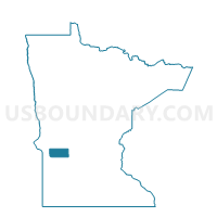
Appleton Twp. Voting District, Swift County, Minnesota
About
Outline

Summary
| Unique Area Identifier | 604598 |
| Name | Appleton Twp. Voting District |
| County | Swift County |
| State | Minnesota |
| Area (square miles) | 31.93 |
| Land Area (square miles) | 30.72 |
| Water Area (square miles) | 1.21 |
| % of Land Area | 96.21 |
| % of Water Area | 3.79 |
| Latitude of the Internal Point | 45.19696040 |
| Longtitude of the Internal Point | -96.05707340 |
Maps


Graphs
Select a template below for downloading or customizing gragh for Appleton Twp. Voting District, Swift County, Minnesota


Neighbors
Neighoring Voting District (by Name) Neighboring Voting District on the Map
- Akron Twp. Voting District, Big Stone County, MN
- Appleton P-1, Swift County, MN
- Appleton P-2, Swift County, MN
- Edison Twp. Voting District, Swift County, MN
- Hantho Twp. Voting District, Lac qui Parle County, MN
- Kragero Twp. Voting District, Chippewa County, MN
- Lake Shore Twp. Voting District, Lac qui Parle County, MN
- Moyer Twp. Voting District, Swift County, MN
- Shible Twp. Voting District, Swift County, MN
Top 10 Neighboring County Subdivision (by Population) Neighboring County Subdivision on the Map
- Appleton city, Swift County, MN (1,412)
- Appleton township, Swift County, MN (203)
- Lake Shore township, Lac qui Parle County, MN (191)
- Akron township, Big Stone County, MN (168)
- Kragero township, Chippewa County, MN (125)
- Shible township, Swift County, MN (124)
- Edison township, Swift County, MN (106)
- Hantho township, Lac qui Parle County, MN (105)
- Moyer township, Swift County, MN (88)
Top 10 Neighboring Place (by Population) Neighboring Place on the Map
Top 10 Neighboring Unified School District (by Population) Neighboring Unified School District on the Map
Top 10 Neighboring State Legislative District Lower Chamber (by Population) Neighboring State Legislative District Lower Chamber on the Map
Top 10 Neighboring State Legislative District Upper Chamber (by Population) Neighboring State Legislative District Upper Chamber on the Map
Top 10 Neighboring 111th Congressional District (by Population) Neighboring 111th Congressional District on the Map
Top 10 Neighboring Census Tract (by Population) Neighboring Census Tract on the Map
- Census Tract 1801, Lac qui Parle County, MN (2,325)
- Census Tract 9604, Swift County, MN (2,241)
- Census Tract 9505, Chippewa County, MN (2,238)
- Census Tract 9501, Big Stone County, MN (1,516)